|
|
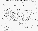
This is a partial map of the seismic data now available in the paper-archive of Spetsgeofizika's Office.
|
|
|
|
(km) |
sheets |
|
|
|
|
|
|
|
|
|
|
|
|
|
|
|
|
|
|
The first line to process will be the Profile XX, a straight-line of 340 km length, which crosses the Scythian Plate in the south, the Karpinsky Swell and stretches into the Voronezh Massive at its northern end (see map). This profile was carried out in 1973-'74, using 23 shot points, direct and reversed shooting (TNT explosions in bore-holes combined in groups, 25-30 m deep, ca. 40 kg. each). Groups of 5 geophones with dominant frequency of ~10 Hz were used, spaced 100 m. The available photographic papers have been recorded by wiggle trace method, using high-cut filter (~15 Hz). Other data could be available somewhere else: a detailed search for further information will be carried out, contacting other Russian institutions, in order to discover other possible data. But up to now (°) the preliminary searches of the original data have been negative, and nobody knows if they do still exist somewhere or have been destroyed. Remember: here we are dealing only with traditional data, in the sense of type of chemical energy source: that means TNT explosion. Other non-traditional data (obtained by peace nuclear explosions in the sixties-eighties) used to produce incredible long seismic profiles, are still collected and available at GEON Centre, another well known state research enterprise.
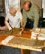
Mr Yurov and Mr Zeyen are observing some papers
and making a first rough check of the quality of the data .
These will then be processed as follows: after the
best parameters-choice, they will be acquired as Image-form by the
A0-Scanner. Normally each paper consists of 48 traces (that means about
4800 m of in-line deployment), and a profile
is a collection of several tens of them.... Then, with the selected Software
package (DGS, by Synapse), from each image
the single seismograms are extracted (Vectorization
phase):
this is the heart of the whole system, and the final success will depend 
 mostly
from the accuracy of this step; the two figures represent the first
successful test on DGS procedure (left: Input; right: Output data).
mostly
from the accuracy of this step; the two figures represent the first
successful test on DGS procedure (left: Input; right: Output data).
Finally, using another standard seismic package (SAC-2000), with a little programming intervention to take into account our large delay-times, the common 'section-film' will be produced, in a reduced-time version, using proper reduction velocities (normally 6.0 km/s for distances up to ca. 200 km; 8.0 for longer distances).

This is a very nice example of the old data hand-made processed in
the sixties. The quality is very good, but one did spent some weeks of
work to produce a copy like this one (you see: re-draw by hand one seismogram
every 20 or more...) and, at the end of job, only this unique copy was
available for the geophysical studies and interpretation.... If it should
had been necessary to remake another section with some of the 'processing'
parameter modified (reduction velocity, amplitude scale, time-window, etc.),
all the procedure should had to start again....